Of 2020’s Atlantic storms, 13 were hurricanes, six of them Category 3 or higher. Warmer ocean waters are fueling an increasing number of storms.
Patrick King and Soncia King walk through flood waters from Hurricane Delta toward their home which they were still repairing from damage from Hurricane Laura on Oct. 10, 2020 in Lake Charles, Louisiana. Credit: Mario Tama/Getty Images
By James Bruggers, Bob Berwyn, Inside Climate News
For Darilyn Turner and her neighbors, living in the bottomlands along the banks of the Mississippi River south of New Orleans is particularly perilous from June through November.
Those months encompass the Atlantic hurricane season. Even in a normal year, people are on edge, she said, worried about storms that blow over the Gulf of Mexico, bringing walls of water, high winds and, often, widespread destruction when they find land.
But 2020 was no normal year.
A record Atlantic basin hurricane season was fueled by warmer than normal ocean and Gulf waters that scientists say were, at least in part, caused by climate change. In all, there were 30 named storms, the most on record and almost three times the typical number. The basin includes the Atlantic Ocean, Caribbean Sea and Gulf of Mexico.
Thirteen of those became hurricanes, and six were major hurricanes, Category 3 or higher, according to the National Oceanic and Atmospheric Administration. That compares to the long-term average of 12 named storms, with six of them hurricanes and three of them majors.
Central America, the Gulf Coast and the state of Louisiana were especially hard hit, with the storms taking a major toll on low-income and Black and brown communities. The 2020 storms were made worse by a global pandemic that had killed nearly 315,000 Americans, including more than 7,000 Louisiana residents, as of Dec. 20.
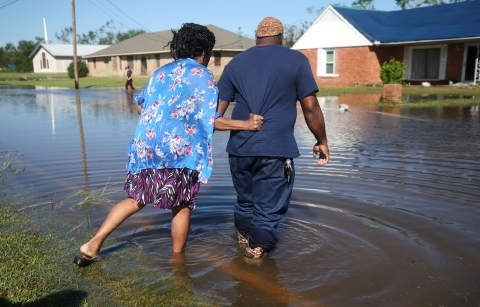
Five storms—three hurricanes and two tropical storms—struck Louisiana alone, setting a seasonal record for that state. Hurricane Laura was a Category 4 when it made landfall near Cameron, Louisiana, on Aug. 27.
Laura was the strongest hurricane, when measured by wind speed, to strike Louisiana in 150 years, its 150 mph winds causing 28 deaths and at least $12 billion in economic damage.
By comparison, Hurricane Katrina, in 2005, was a Category 3 storm when it made landfall, with sustained winds of 120 mph. Unlike Laura, Katrina was a major flood event, with failing levees that resulted in floodwaters covering about 80 percent of New Orleans, according to NOAA.
The five storms that his Louisiana this year left behind battered lives and shattered nerves.
“We had to evacuate for several potential threats to lower Plaquemines Parish,” said Turner, who runs the Zion Travelers Cooperative Center there. It’s a nonprofit faith-based community development corporation organized in the aftermath of Katrina’s devastation.
One of the 2020 hurricanes, Zeta, directly struck her community, damaging homes and sheds, Turner said, and leaving people without much money “trying to figure out where to go from here.
“Your stress level is through the roof. Everybody in my community has some danger.”
A Hyperactive Season
The 2020 spike in hurricane activity wasn’t surprising to Kevin Trenberth, an atmospheric scientist based in New Zealand.
“In general, one expects more activity as the climate warms,” he said. “This can be manifested in multiple ways: more intense storms, bigger storms, longer-lasting storms, and more storms. Also in general there is increased risk of flooding.”

An aerial view of flood waters from Hurricane Delta surrounding structures destroyed by Hurricane Laura on Oct. 10, 2020 in Creole, Louisiana. Credit: Mario Tama/Getty Images
All that can be traced to the increasing warmth of the oceans. They’ve warmed by about 1 degree Fahrenheit in the past 100 years, and not just at the surface.
Trenberth said that, in decades past, hurricanes stirred up a cold wake of water that helped inhibit formation of subsequent storms. But with oceans now warming at depth, even the churned water from below is much warmer than it was.
Don’t miss information like this. Sign up for FREE updates
Oceans warm earlier, allowing storms to form before the official season begins, as happened with Tropical Storms Arthur and Bertha in May. Oceans also hold heat later into the year, a likely factor in the formation of Hurricanes Eta and Iota in November.
In a pattern common to other recent storms thought to be linked with global warming, Eta and Iota intensified rapidly near the coast of Central America, killing more than 270 people and causing about $9 billion in damage.
Hardest hit were Nicaragua, Honduras and Guatemala, where rains, floods and mudslides disrupted the lives of more than 6 million people. The storms wiped out livestock and harvests and destroyed tourist destinations in a region already struggling with the pandemic, according to the International Federation of the Red Cross.
The two storms “truly highlight the environmental injustice of the people who contributed the least to global warming but who experience the worst impacts,” said Rosanne Martyr, a climate scientist with Climate Analytics, an international think tank, who focuses on coastal vulnerability and adaptation.
“Islands in the Caribbean were also devastated, and they were still reeling from the previous seasons,” she said. “Some of these storms are much larger than anticipated when they hit land.”