Remediation coming to a close for a part of Universal Oil Products Superfund Site in East Rutherford, NJ
From the USEPA
NEW YORK (July 22, 2022) –Today, the U.S. Environmental Protection Agency (EPA) proposes that no further cleanup action is needed to address groundwater at the Universal Oil Products Superfund site in East Rutherford, NJ.
Sampling data indicates that there are no expected impacts on the surface water from the site. To further ensure long-term protection, EPA proposes amending the original cleanup action, requiring notices to be filed with property records and incorporating other measures to safeguard the cleanup.
“Today’s proposed action ensures that long-term controls are in place to inform and safeguard public health both now and long into the future,” said Regional Administrator Lisa F. Garcia. ” EPA believes that earlier cleanup actions for the land portion of the site, which includes soil and groundwater, are protective, and we are moving forward with other portions of the cleanup.”
Other Superfund news:
EPA plans to clean up contaminated groundwater in Olean Well Field Superfund Site in Cattaraugus County, New York
EPA is spending $5.5M to clean up Bucks and Montgomery County Superfund sites
What is Superfund?
Today’s proposed cleanup comes after work has already been done under a 1993 cleanup plan selected by EPA in close consultation with the New Jersey Department of Environmental Protection. Under that plan, contaminated soil was dug up and treated, the area was capped, and long-term monitoring was required.
Notice requirement for property owners
The addition proposed by EPA today requires that property owners planning new construction on the land portion of the site evaluate conditions to ensure pollutants in indoor air will not exceed levels protective of human health for building occupants. In addition, property owners may be required to install certain engineering controls such as a vapor barrier or a sub-slab-depressurization system, which uses a fan-powered vent to draw air from beneath the foundation slab, redirecting potentially harmful vapor from entering the building.
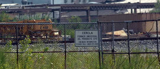
The Universal Oil Products Superfund site is a 75-acre area located in East Rutherford, New Jersey. Site operations starting in the 1930s included chemical manufacturing and solvent recovery, later expanding in the mid-1950s to include a wastewater treatment plant and storage lagoons. Seepage from the wastewater lagoons and the routine handling of products and wastes resulted in the release of hazardous substances to the upland soil, groundwater, tidal marshes, and waterways.
EPA placed the site on the Superfund National Priorities List in 1983 and divided the site into two distinct areas called operable units (OUs). Today’s proposed plan is for the first operable unit, which addresses the upland soil and shallow groundwater.
EPA selected a cleanup plan for OU2 in 2019, which addresses a former lagoon area, low-lying marshes, and the waterway channels of Ackermans Creek and its tributaries. The design for that cleanup is currently underway.
Public meeting July 27 on cleanup plan for Operating Unit 2
The proposed plan’s 30-day public comment period will occur from July 22, 2022, to August 22, 2022. In addition, EPA will host a Virtual Public Meeting on July 27, 2022, at 6:30 p.m.
To register for the public meeting, visit universaloilproducts.eventbrite.com. To learn more about the public meeting, contact Shereen Kandil at Kandil.Shereen@epa.gov or (212) 637-4333
Written comments on EPA’s proposed plan may be mailed or emailed to Jennifer LaPoma, Remedial Project Manager, U.S. Environmental Protection Agency, 290 Broadway – 18th Floor, New York, NY 10007, Email: LaPoma.Jennifer@epa.gov.
Visit the Universal Oil Products Superfund site profile page for additional background and to view the proposed plan.
If you liked this post you’ll love our daily environmental newsletter, EnviroPolitics. It’s packed with the latest news, commentary, and legislative updates from New Jersey, Pennsylvania, New York, Delaware…and beyond. Don’t take our word for it, try it free for an entire month. No obligation.
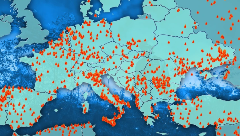
 Firefighters across Europe have faced scorching temperatures amid a surge in wildfires